

The story of charts and hydrographic data in recent decades is the story of digitalization. Standing on the threshold of the S-100-era, we expect great progress in terms of efficiency, sustainable profitability, and safety at sea.
Tests and feasibility projects have shown the S-100 standard with derived datasets like S-102 (Bathymetric Surface) and S-111 (Surface Current) generate significant value not only for navigational purposes, but for the maritime industry as a whole.
- Read also: S-100 Data: What It Is, How It Works and Why You Should Care
- Read also: S-100 Data – Not Only for Navigation
Important Benefits of the New S-100 Standard
S-100 is a universal hydrographic data model; an international framework developed by the International Hydrographic Organization (IHO) to exchange and display digital maritime data. S-100 offers the possibility for hydrographic and maritime communities to develop a range of new digital products and services.


Following decades of using S-57 data for navigation, this new generation of digital products and services promises to empower hydrographic, maritime and GIS communities with data expanding traditional hydrography boundaries.

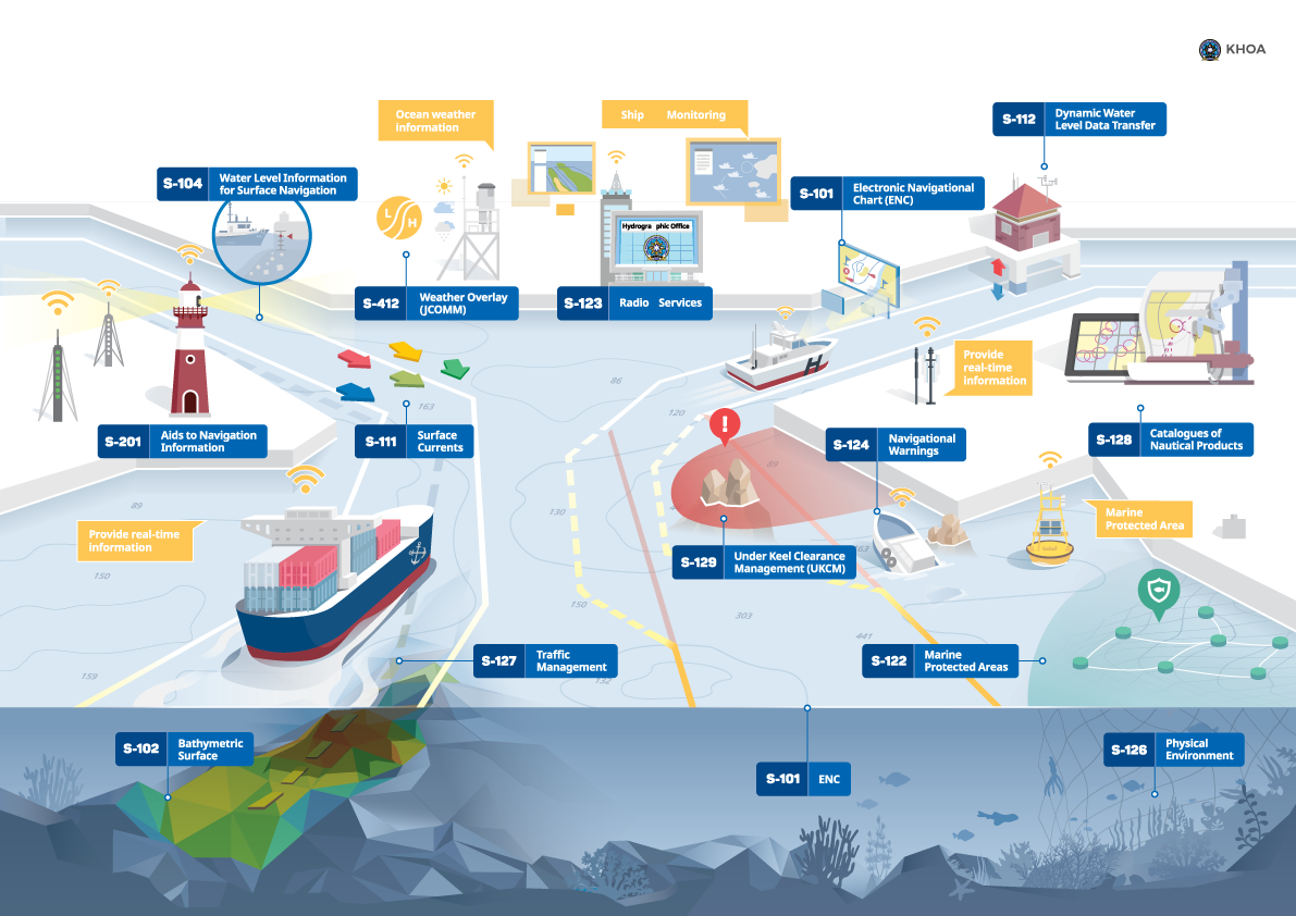
Illustration credit: KOREA HYDROGRAPHIC AND OCEANOGRAPHIC AGENCY
Interoperability advantages:
S-100 will support a wider variety of hydrographic data sources and products and facilitate greater interoperability between these navigational products in the end-user system. The ECDIS operator will be able to access multiple products from his system. The interoperability possibilities will create a wide range of new user functionalities supporting what-if analyses.
Autonomous navigation:
Sensor technology, connectivity at sea, and advanced data analysis software create new opportunities for developing autonomous and remotely controlled ships and vessels. Developing new data standards for navigational-significant information is a critical step towards realizing the benefits of autonomous navigation.
Service and usage efficiency:
The S-101 will significantly improve user experience. It enables more advanced geographical queries, ensures greater flexibility in updating mechanisms and improves the display of ENCs with more content and information than the existing S-57 standard.
Easier development and maintenance:
Compared to the current S-57 standard, the S-100 standard includes better mechanisms for rapid and automatic updates. This improves efficiency as one development can be used to support many different products.
New capabilities and functionalities:
One of the major benefits of the S-101 is the ability to introduce new capabilities and functionalities that are not available in the S-57, such as machine-readable catalogues, portrayal changes, updated information and cartographic features.
More formats and data carriers:
S-100 supports more formats, such as the ISO 8211, grid formats and GML formats, which adds flexibility to the various data production processes.
Data integration:
Easy integration with other types of data products for better situational awareness and decision support.
Being early in the game has allowed PRIMAR to cater to distributors and customers, thereby getting valuable feedback to enhance further and improve the products themselves.
Digitalization - A Global Super Trend
Global super trends refer to long-term trends or shifts in the world economy, society, and culture expected to shape the world, driven by technological, environmental, and geopolitical factors. They are almost guaranteed to affect businesses, governments, and individuals.
In the maritime world, the digitalization super trend manifests through the development and implementation of the S-100 platform.
Online training
In partnership with PRIMAR, ECC also offers a comprehensive online training portal with training material, courses and support instructions on current and future maritime data standards and requirements.

The Digitalization Benefits of S-100
Adding to the benefits stated above, the digitalization inherent in the S-100 standard will positively impact various parameters, like:
Increased Efficiency and Productivity: Digitalization enables the automation of processes, reducing manual labor and streamlining operations. This increases efficiency and productivity, as tasks can be completed faster and with fewer errors. S-100 tests support this.
Globalization of markets: Digitalization breaks down geographical barriers and enables businesses beyond traditional boundaries. S-100 permits users to download and update data without regard to geographical proximity to producers and purveyors. Enhanced production of geographical information in combination with efficient maritime communication exchange provides the possibility for information to be updated instantly.
Enhanced Data Management and Security: Digitalization facilitates data collection, storage, and analysis, providing mariners with valuable insights for decision-making.

The Economy of Digitalization
The digitalization of maritime information leads to better insight into hydrographic data. This will enable ships to choose new and potentially time-saving sailing routes. The information presented to the vessel operators considers depth, currents, shoals, tides, waves, weather, and more to allow more informed choices.
Historically and in traditional navigation, detailed information between the depth contours in navigational charts has not been accessible. It is now.
Digitalization through S-100 can support better fleet management. By finding new routes, a shipping company can identify substantial savings. We know from the S-100 Demonstrator project at Tjeldsundet, Norway, how the use and implementation of S-129 (Under Keel Clearance) create added value for the maritime industry by allowing sailing routes that were considered non-navigable.
The S-129 test pilot, Karl Helge Haagensen, summed up his impressions this way:
We can (now) document safe sailing depths in advance. This means being able to sail as soon as the tide is high enough and saving time by not having to wait for high tide. Ships can be loaded heavier, which means fewer trips, or they can choose shorter new routes and save fuel.
In a recent test of the S-100 framework, the Korean passenger ship Sambo 12 made immense savings (45,5%) by choosing a new and significantly shorter route instead of the traditional shipping lane. What made this possible was the new insight offered by the S-100 service regarding the navigability of waters.
In partnership with PRIMAR, ECC also offers a comprehensive online training portal with training material, courses and support instructions on current and future maritime data standards and requirements.

The Benefits of the S-100 Standard on Safety and the Environment
The most important benefit of deploying the S-100 products through the S-100 framework will be safer voyages. The data disseminated through S-100 will be richer and more precise, and the extra information served by the data sets should give fewer incidents. The amount of information that can be encoded on the S-100 framework is large, and can potentially be detailed for specific purposes.
ECC manages the Norwegian feasibility study S-100 Demonstrator Project – Norwegian feasibility study – IHO S-100 portfolio, which is dedicated to defining how combining the new standards can create great value for the maritime industry and improve products and business opportunities. The study has had a focus on real-life operational tests.
These tests have demonstrated the benefit of the new S-100 data when navigating in narrow and challenging waters with giant vessels like Sleipnir and Pioneering Spirit. The tests have also demonstrated the added value and security to port authorities, and they have shown how the new Under Keel Clearance (S-129) product opens up new and climate-friendly routes to save time and fuel.
Operational test results are shared on this page
An Ambition to Reach UN's Sustainability Goals
As mariners find shorter routes, fuel consumption decreases, and the environmental impact from the shipping industry is reduced. This will benefit the environment and help reach many of UN’s Sustainability Goals.
The ECC's vision is to contribute to greater safety and security, lower costs and enhanced efficiency at sea, and on land, through the rapid development of technology to meet the clients' needs.
We realize that the economic impact on the world’s shipping fleet is an important metric to companies, customers, and planners. Considering the timesaving manoeuvers suggested by new insight, time is freed up, and larger ships can be deployed. This represents potential savings.
Feel free to reach out to us in ECC for more information on how you can begin your S-100 journey today. Also check out the Electronic Navigational Chart (ENC) service PRIMAR which offers the necessary infrastructure, tools and services to leverage the opportunities of S-100 products and datasets.