
As the maritime industry enters the S-100 Decade, developing support for S-100 datasets and products should be on top of a navigation software developers’ agenda.
Maritime voyages are increasingly becoming safer, faster and more fuel-efficient, as advanced digital technologies and increased bandwidth capacities enhance navigation capabilities through rapid data exchange between ship and shore. Underlying this digital transition, we find the new S-100 standard. This standard aims to enhance current navigation methods by developing next-generation Electronic Navigational Chart (ENC) products and other hydrographic-related digital sources and products.
And this transition is happening now. In the coming years, the entire hydrographic and maritime community will slowly and steadily replace existing S-57 ENCs with S-101 (next generation ENC) and other S-100-based products to better understand and utilise navigable waters than what is currently possible. As the hydrographic and maritime community is transitioning to the digital future for hydrographic data, market players developing navigation software should follow suit and ensure that all systems are fully prepared to handle the coming age of S-100-based products.
Read also: The Ultimate Guide to S-100 Data and Products
Entering the S-100 Decade
The S-100 is an innovative hydrographic data model that aims to replace the existing S-57 standard to better accommodate digital hydrographic data exchange. As the S-57 is considered obsolete for the coming age of digital hydrographic information exchange and e-navigation, the International Hydrographic Organization (IHO) has developed the S-100 standard to enable the development of a new generation of ENC products and other digital products useful for the hydrographic and maritime communities. A common data model will enable the new digital products to interoperate to support new and advanced navigational assessment and decision support.
These products are now increasingly becoming available for the modern navigator. After the first initial draft of the S-100 standard was released in 2010, we are finally entering what has been aptly named the S-100 Decade. As we progress through the 2020s, S-100 will become the standard for products used in Electronic Chart Display and Information Systems (ECDIS). Although the full-scale implementation of S-100 products depends on the timely development of various specifications and frameworks for type-approved ECDIS, it is reasonable to expect that we will see several S-100 products being produced in the coming years.
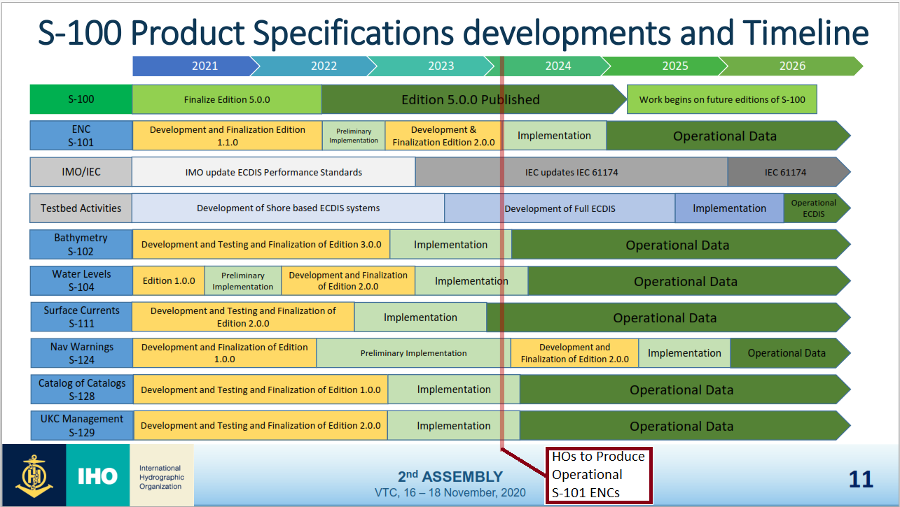
Figure: Timeline for the S-100 Decade and various S-100 products timeline. (Source: International Hydrographic Organization)
As the figure illustrates, the latest edition of S-100 (version 5.0.0) will be completed in 2022 to support operational product specifications, while IHO member states can initiate S-101 production in 2024. Ultimately, a Dual Fuel ECDIS, which allows the import and use of both S-57 and S-101 data, will be available for commercial vessel navigation under the SOLAS convention.
S-100 Datasets and Products
With a new S-100 ECDIS, a range of new datasets and products will become available for the SOLAS market, providing standardised, available and public information to help navigators better utilise vessel loading capacity, fuel usage and navigational room for manoeuvre.
The following products are considered especially important in the coming years:
-
S-101 Data: Electronic Navigational Chart (ENC)
-
S-102 Data: Bathymetric Surface
-
S-104 Data: Water Level Information for Surface Navigation
-
S-111 Data: Surface Currents
-
S-122 Data: Marine Protected Areas
-
S-123 Data: Marine Radio Services
-
S-124 Data: Navigational Warnings
-
S-129 Data: Under Keel Clearance Management
Of these, the S-101, S-102, S-104 and S-111 datasets are expected to constitute the most foundational products of a future S-100 ECDIS. Together, they will help navigators utilise navigable waters better than what is currently possible with an S-57-based ECDIS. Test data is commercially available for those who want to begin leveraging S-100 data today.
Read also: Helping the Canadian Hydrographic Service (CHS) Leverage S-100 Data
S-100 Data Are Already entering the Non-SOLAS market
As described in the referenced article above, S-100 data are already available for use on Non-SOLAS systems. Although SOLAS-compliant S-100 ECDIS is still some years ahead, S-100 products may still become useable for other markets earlier. Most notably, we believe that S-100 products will generate considerable value in the short term for a wide variety of maritime-related industries, sectors and players – from port operations and search and rescue operations to public administration and national defence organisations, to mention just a few. Consider the following examples:
-
S-101 and S-102 data may be leveraged to gain better insight into underwater infrastructure placement in relation to development projects near shorelines.
-
S-102 data may help private companies chart the existence of marine resources and minerals.
-
S-104 data may be used by biologists seeking to understand various organism’s habitats better.
-
S-111 data may be used to calculate the optimal position for new fish corrals in the aquaculture industry.
These are just a few examples. The possibilities for S-100 data and product utilisation are seemingly limitless – only our imagination sets the limit. For more information on potential non-navigational use cases for S-100-based datasets, take a look at this article.
Read also: How S-100 Data Enabled the Safe Port Approach of the World’s Largest Crane Vessel
Marine System Developers Should Act Now
Having entered the S-100 decade, where S-100-based datasets and products increasingly become available for the hydrographic and maritime communities, the need for S-100-supported navigation software becomes pressing. Market players developing navigation software for the maritime community should consider developing support for and implementing S-100 products today to accommodate the end-user needs and requirements of tomorrow.
Want to learn more about the S-100? We have created a Quick Guide to S-100 for anyone who is interested. Please download the guide by clicking the button below.

Feel free to reach out to us in ECC for more information on how you can begin your S-100 journey today. Also check out the Electronic Navigational Chart (ENC) service PRIMAR which offers the necessary infrastructure, tools and services to leverage the opportunities of S-100 products and datasets.