-1.png?width=80&height=80&name=Untitled%20design%20(1)-1.png)
With the help of the Electronic Chart Centre (ECC) and PRIMAR, the Canadian Hydrographic Service (CHS) successfully leverages the new S-100 paradigm with a brand-new service for S-100 data service and products.
The world of hydrographic data is slowly and steadily adapting to a new, digital future. After decades of relying on S-57 data for navigation, a new and more versatile standard is emerging – the S-100 standard – promising to address current navigational and non-navigational needs through a variety of hydrographic-related digital data sources and products. In this industry-wide transition, Canada is at the forefront. With the help of the Electronic Chart Centre (ECC)/PRIMAR and Teledyne CARIS, a leading developer of marine mapping software, the Canadian Hydrographic Service (CHS) now efficiently leverages the opportunities inherent in the coming S-100 decade.

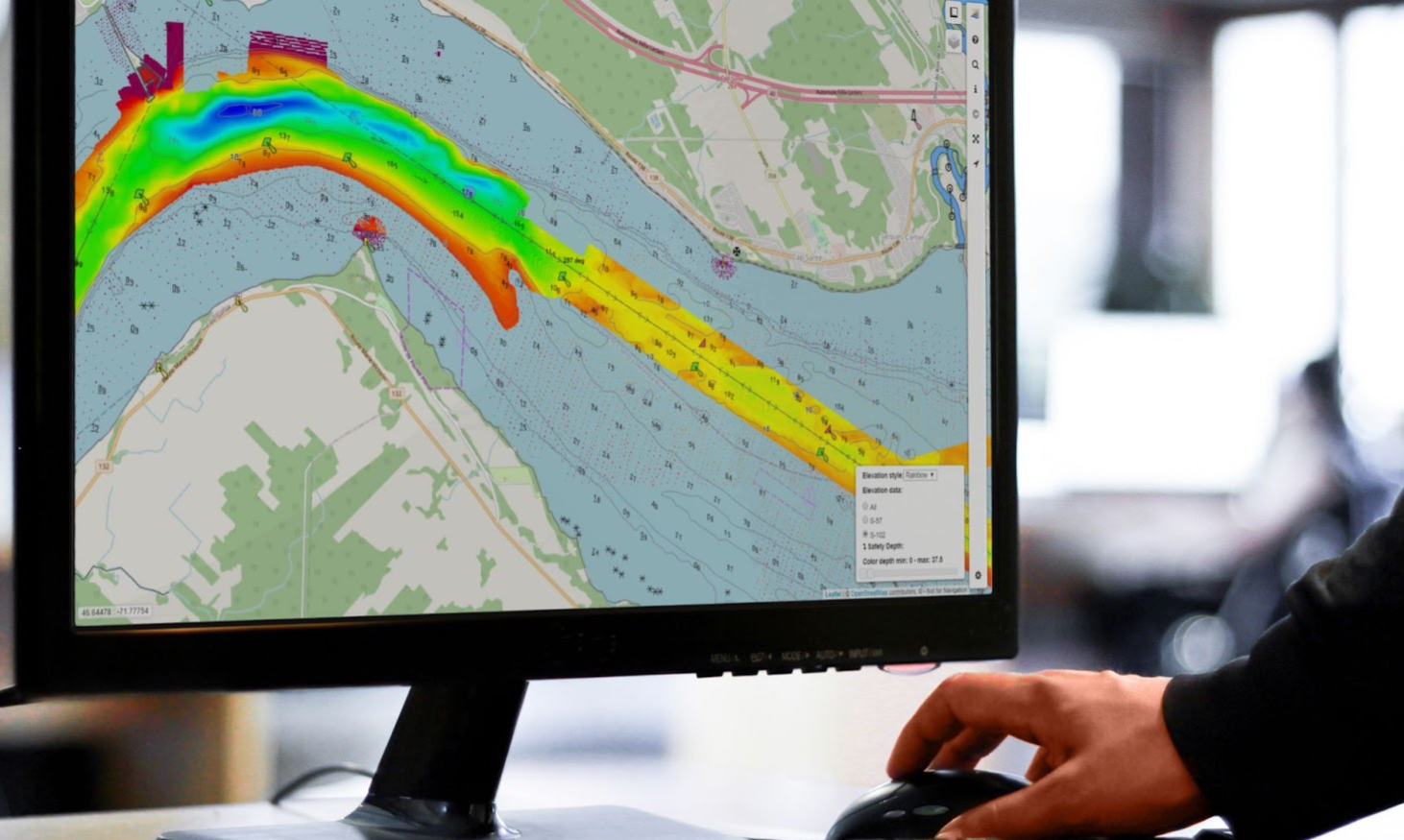
Photo: Display of Bathymetric Surface Data (S-102) produced by the Canadian Hydrographic Service for Saint Lawrence River, in an ECC developed viewer tool. (Source: Electronic Chart Centre).
Developing Innovative Services for S-100 Products
With its vast maritime terrain and the world’s longest coastline, not to mention a long history focusing on innovation and technology, Canada is uniquely positioned to lead the way in the realisation of the S-100 standard. Wanting to demonstrate the benefits inherent in the new S-100 standard and figuring out how to best implement and operationalise the standard, the CHS reached out to ECC/PRIMAR and Teledyne CARIS for help to realise two primary ambitions:
-
To demonstrate the benefits inherent in the new S-100 standard by developing an innovative service for hydrographic data and leveraging the latest technological approaches available for the hydrographic industry.
-
To reduce the time from hydrographic data is produced to the data is available for distribution to end-users as much as possible.
Together, these ambitions would help realise significant benefits for the maritime community, ultimately strengthening navigation safety, unlocking the potential of marine geospatial data and providing dynamic data for improved environmental and situational understanding for navigators and pilots.
Read also: How S-100 Data Enabled the Safe Port Approach of the World’s Largest Crane Vessel
From S-100 Data Production to Data Delivery
To develop and implement a new and innovative data service for the delivery of S-100 products, the CHS, Teledyne CARIS and ECC/PRIMAR initiated a collaborative project in 2018 to efficiently distribute high-resolution bathymetric data (S-102 data) to end-users. For the project, the CHS took on the role of S-100 producer, generating hydrographic data from implemented sensors in various rivers and waters. Teledyne CARIS provided the back-end infrastructure to efficiently move the data generated by the CHS to the distribution network supplied by ECC/PRIMAR, who quickly distributes the S-100 products to end-users.
Working closely together, the project team leveraged the latest technological approaches to collectively develop an end-to-end S-100 service consisting of software that ensures efficient uploading, hosting, managing and delivering of S-100 products and a subscription service that quickly disseminates the latest and best S-100 products to end-users. On the one hand, the service leverages a solution that automatically creates S-100 products based on data generated by the CHS and automatically uploads these products into a new and bespoke cloud solution developed by Teledyne CARIS. On the other, PRIMAR accesses the latest and most up-to-date products uploaded in the cloud solution and makes them available in the PRIMAR Chart Catalogue, a subscription-based application that delivers ENCs and S-100 products to both distributors and end-users quickly and efficiently.
Read also: The Ultimate Guide to S-100 Data and Products
S-102 and S-111 Data Available
The project is now in its operational phase, and the service is live and accessible for distributors, value-added resellers and end-users. Currently, the service focuses on a few primary products but will continue to grow to support additional S-100 products in the near future. The following S-100 products are available today:
-
S-102 Bathymetric Surface Data supports safety at sea and enables precise navigation by giving end-users access to detailed bathymetric data and making it possible to generate 3D visualisations of underwater ocean floors.
-
S-111 Surface Currents Data supports safety of navigation by providing information on surface currents that may influence vessel motions.
Combined, these datasets provide end-users with access to information on depth, bottom morphology and all other relevant data necessary for efficient and safe navigation.
Realising the Benefits of S-100 Data for Hydrographic and Maritime Communities
The CHS now offer easy access to detailed and high-resolution hydrographic and bathymetric data to maritime and hydrographic communities. And end-users are increasingly benefitting from a service that considers the entire value chain – all the way from S-100 data production to data delivery.
For the hydrographic and maritime communities, this quickly translates into significant benefits:
-
Easy access to detailed, high-resolution data: The service ensures that data move efficiently through the value chain to the end-user, while simultaneously taking data integrity and security into consideration. Furthermore, its real-time capabilities make sure that the data is always up-to-date and allows end-users to access the data with a simple click.
-
Improved safety at sea: As the service increases the accessibility of high-quality and high-resolution hydrographic and bathymetric data, navigators and pilots can enhance their situational understanding during voyages and port approaches.
-
Reduced fuel emissions: Efficient dissemination of S-100 data may help pilots and navigators plan for shorter and more optimal routes, ultimately reducing CO2 and NOx emissions by improving fuel-efficiency.
-
Cost reductions: Considering its potential to improve route planning capabilities, S-100 data may help navigators utilise navigable waters better than previously possible. Previously unnavigable waters may prove to be navigable as detailed and high-resolution data shows that current no-go areas indeed are sailable. This insight will help navigators plan shorter navigation routes and, in many cases, better utilise vessel loading capacity.
Chart distributors, OEMs and end-users looking to leverage the opportunities of S-100 datasets and products need to look no further. The technology necessary to ensure efficient dissemination of S-100 data is already available and ready to be leveraged by anyone who recognises its value. If you are interested in investigating the opportunities of the brand-new S-100 service, get access to a 3 Month Free Trial by following the link below:

Feel free to reach out to us in ECC for more information on how you can begin your S-100 journey today. Also check out the Electronic Navigational Chart (ENC) service PRIMAR which offers the necessary infrastructure, tools and services to leverage the opportunities of S-100 products and datasets.