.png?width=80&height=80&name=Untitled%20design%20(3).png)
S-100 data collected and made available by the Electronic Chart Centre (ECC) helped the world’s largest crane vessel, Sleipnir, sail safely through narrow waters and into the Haugesund harbour.
In a ground-breaking and highly complex operation for the oil and gas industry, the ECC contributed to the safe and efficient port approach of Sleipnir into the Haugesund harbour, located in the southern part of Norway.
The Challenge
In 2018, the Norwegian energy company Equinor initiated the largest project to date for increased oil and gas extraction on the Norwegian continental shelf – the Snorre Expansion Project. Being on-stream since 1992, the expansion project aims to help Equinor significantly improve field recovery factors, increase platform lifetimes and extract the substantial resources still left in the ground.
As part of this large-scale project, a massive, 600-tonne riser module, engineered and constructed by the oil and gas service company Aibel, had to be transported from the port of Haugesund to the Snorre field in the North Sea – a herculean task that required the muscles of the world’s largest crane vessel, Sleipnir, a 220 meter-long and 102-meter-wide semi-submersible crane vessel, owned and operated by Heerema Marine Contractors. However, Sleipnir’s width and draft made it impossible to plan the port approach to Haugesund based on existing electronic navigational charts (ENCs). Riddled with narrow routes and areas that are shallower than the vessel’s draft, existing charts did not provide enough detail to make a safe assessment of the depth margins required by the rig.
To safely navigate the enormous vessel and prove to stakeholders that the project was feasible, Heerema depended on detailed data on surrounding conditions and high-quality bathymetric data. Gaining access to the necessary data, however, proved near impossible. Struggling to get their hands on up-to-date and detailed data, time was quickly running out for Heerema. Due to their first-hand knowledge of the universal hydrographic data model S-100, a wide net of contacts made during several S-100 development projects, and decades of experience in providing nautical charts for marine digital navigation, ECC was able to assist.
Read also: Helping the Canadian Hydrographic Service (CHS) Leverage S-100 Data
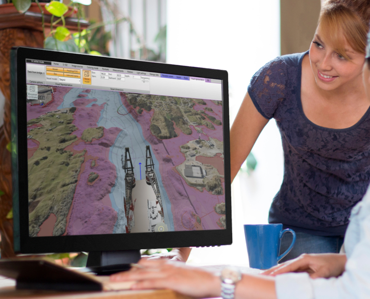
Photo: Simulating Sleipnir’s approach to Haugesund harbour in the S-100 Demonstrator (credit: Kongsberg Digital)
The Solution
To aid in the port approach, ECC, Kongsberg Digital and the Norwegian Mapping Authority came together to seamlessly provide Heerema with detailed information on the ocean floor by collecting and disseminating relevant hydrographic and bathymetric data, made accessible via a new, cutting-edge mapping tool – the S-100 Demonstrator. Developed by Kongsberg Digital, in collaboration with ECC, the Norwegian Coastal Administration and the Norwegian Mapping Authority, the S-100 Demonstrator provides navigators with detailed and high-resolution 3D visualisations of the ocean floor based on the new S-102 standard for bathymetric data.
The S-102 standard, or the Bathymetric Surface Product Specification, is a product for detailed bathymetric data on a gridded data format. For this project, the port approach was planned based on an S-102 dataset with a 1x1 meter resolution, visualised through the S-100 Demonstrator. To make the planning more manageable, the S-100 Demonstrator included an accurate model of Sleipnir that made it possible to precisely simulate all the critical areas of the voyage in 3D. The S-100 Demonstrator provided pilots with the necessary situational understanding to safely and precisely navigate the vessel through narrow waters into the Haugesund port. Drones filmed the entire operation in a 360-degree video format. Check out the video here.
Read also: The Ultimate Guide to S-100 Data and Products
The Results
By accessing up-to-date, detailed and high-resolution S-102 bathymetric data, visualised in 3D format, Sleipnir – despite its colossal size – successfully navigated even the tightest of spaces into the Haugesund port and picked up and transported the riser module out to the Snorre platform.
And the gains are considerable. First of all, the entire operation would be impossible to execute without access to detailed and up-to-date S-102 data. Second, the S-100 Demonstrator provided both Heerema, pilots and navigators with a situational understanding that would be hard to replicate with traditional navigation and simulation methods. Lastly, by leveraging S-102 data, Sleipnir was able to pick up the riser module directly from Aibel’s quayside, eliminating the need for any cargo barges and ultimately cutting costs and increasing operational efficiency. All in all, the project was a huge success and clearly exemplified the considerable value that may be generated by leveraging the opportunities of S-100 data and products.
Want to learn more about the S-100? We have created a Quick Guide to S-100 for anyone who is interested, download the guide by clicking the button below.

Read also: Supporting S-100 Products in Navigation Software: A Call to Action for Marine System Developers
If you are interested in learning more about how S-100 data may help your maritime operations, feel free to reach out to us in ECC. We are ready to help you leverage the opportunities of the coming S-100 era. To download the pilot report on the execution of the Sleipnir mission, and its unique challenges, follow the link:

Feel free to reach out to us in ECC for more information on how you can begin your S-100 journey today. Also check out the Electronic Navigational Chart (ENC) service PRIMAR which offers the necessary infrastructure, tools and services to leverage the opportunities of S-100 products and datasets.