.png?width=80&height=80&name=Untitled%20design%20(3).png)

Together with other maritime industry players, the Port of Stavanger and the Electronic Chart Centre (ECC) simulated the port approach of the world’s largest cruise ship into a planned new quay located in Bjergsted, Stavanger.
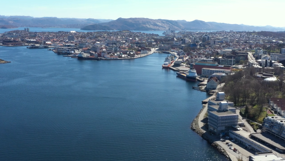
The Port of Stavanger is one of the largest cruise ports in Norway, receiving around 200 cruise calls per year. However, port capacity is pushed to its limits as more and more large vessels want to approach the port. Additionally, navigational space in the harbour basin is marginal, leaving little manoeuvring room, and other factors such as winds and streams make port approaches particularly difficult.
To cope, the Port of Stavanger is currently investigating the possibility of building a new quay in the Bjergsted area of Stavanger to accommodate the port approach of both large cruise ships and offshore ships better. A critical part of this investigation is identifying whether it is possible for even larger vessels to enter the port safely without making ocean floor excavations.
To simulate the safe port approach of large vessels into the new quay, the Port of Stavanger leveraged a cutting-edge, proprietary and non-commercial tool – the S-100 Demonstrator – developed by Kongsberg Digital, the ECC, the Norwegian Coastal Administration and the Norwegian Mapping Authority as part of the S-100 Demonstrator project.
Want to learn out more about the S-100? We have created a Quick Guide to S-100 for anyone who is interested, download the guide by clicking the button below.

Quay Development Challenges
Ports, harbours and ships regularly struggle with a lack of high-resolution bathymetric data, making it difficult to plan and calculate the safety of port approaches correctly. For example, ports may require information on whether a wide fender between the quay and the ship side makes it possible for large vessels to approach the port safely. With high-resolution data, however, maritime operations become simpler and more efficient to implement.
Furthermore, local authorities in coastal municipalities typically struggle with limited access to relevant and detailed data that helps them make well-founded decisions for development projects in coastal areas. Typically, they need to consider many factors potentially influencing the project, such as biodiversity, subsea infrastructure, water movements. With access to data and information about these and other factors, new opportunities emerge to ensure simpler and safer development projects and improve grounds for decision making.
The Port of Stavanger is no different.
The harbour basin of the Port of Stavanger is too shallow to accommodate large-scale vessels, such as Oasis-class vessels. However, the government representatives have not yet approved plans for excavating the Port of Stavanger in the national transport plan. Consequently, local Norwegian Coastal Administration pilots, in cooperation with the Port of Stavanger, has recorded an application to recommend excavating the port to a depth of 12 to 14 meters to accommodate large-scale vessels. Determining whether it was possible for even larger vessels to enter the port safely without making excavations was critical for the Port of Stavanger.
To gain better insights into the possibilities and challenges associated with the new, potential quay in Bjergsted, safe port approaches and ensure that the area could be adapted to the different vessels that will approach the dock in the future, the ECC helped the Port of Stavanger leverage new data types and gain better subsea insights.
Read also: The Ultimate Guide to S-100 Data and Products
Leveraging S-100 Data in Stavanger
The maritime industry is undergoing a rapid digital transformation, where advanced digital technologies increasingly enable safer, faster and more cost-efficient maritime voyages and e-navigation capabilities. Underpinning this transformation is the new S-100 standard, which aims to support a wide variety of new hydrographic digital data sources and products.
To demonstrate the feasibility of the new quay in Bjergsted, the ECC helped the Port of Stavanger leverage these data sources and products to provide detailed information on the ocean floor. The ECC collected and disseminated relevant hydrographic and bathymetric data, delivered by the Norwegian Hydrographic Service, made accessible via the S-100 Demonstrator.
The Port of Stavanger wanted to visualise the port approach of the cruise ship Harmony of the Seas, an Oasis-class vessel requiring 12 meters clearing between the seafloor and vessel bottom and 200 meters in canal breadth, focusing on the margin limitation involved in maritime operations.
As part of the project, ECC focused on displaying several layers of information combined in the S-100 Demonstrator. The S-100 Demonstrator provides navigators with detailed and high-resolution 3D visualisations of underwater ocean floor based on the new S-102 standard for bathymetric data.
Visualising detailed bathymetric data combined with ENCs contributed to a better understanding of the challenges the Port of Stavanger, Norwegian Coastal Administration pilots and other fairway users experience with current port approach margins.
Read also: Helping the Canadian Hydrographic Service (CHS) Leverage S-100 Data
The Results: Demonstrating the Benefits of S-100 Data
For the Port of Stavanger, the insights gained by leveraging S-100 data were of critical importance.
– By leveraging new data types that visualise the distance between the seafloor and vessel bottom, it becomes easier to understand the challenges involved in accepting a large vessel into Stavanger, Dag Matre, head of maritime operations in the Port of Stavanger, says.
A particular focus was placed on making the visualisations as understandable as possible for external stakeholders, including decision-makers, politicians and other relevant users. Specifically, the following benefits were particularly highlighted:
-
Financial gains: The city of Stavanger is the fourth largest city and third-largest metropolitan area in Norway, having built much of its trade industry around maritime businesses. Consequently, the Port of Stavanger experiences significant traffic in the city’s port approach. By simulating the safe port approach of Harmony of the Seas, the Port of Stavanger proved that even large-scale vessels can approach the port safely – if suggested excavations are carried out – and consequently accommodate increasing trade traffic stimulating the city’s economy.
-
Improved safety: Navigational charts, detailed port data, and seafloor information are critical for planning and executing the port traffic without posing critical risks to people and vessels. Leveraging S-100 data helped the Port of Stavanger demonstrate how the new quay would increase port safety margins and accommodate any safety concerns.
-
Environmental benefits: With increased safety margins, the risks of potential vessel stranding and accidents leading to oil spills threatening the subsea environment are reduced. By leveraging S-100 data, the Port of Stavanger successfully demonstrated how the new quay would pose no environmental threats for critical stakeholders.
The simulation results were uplifting. Currently, vessels over 300 meters in size are entering the existing port. When the new Bjergsted quay is completed, it is expected that the Port of Stavanger can accommodate cruise vessels over 350 meters.
However, as the S-100 data proved, the Port of Stavanger will not be able to accommodate Oasis-class vessels in the quay before excavating the ocean floor. ECC simulations successfully shows the probability to accommodate cruise ships of this size in a new quay in Bjergsted, as long as the suggested excavations are carried out.
Read also: How S-100 Data Enabled the Safe Port Approach of the World's Largest Crane Vessel
The Port of Stavanger is not unique. The same challenges are faced in several ports both in Norway and abroad. Other ports requiring detailed information, tools and data sharing workflows to secure and enable fairway development, planning and implementation should consider using S-100 data actively. The safety of future maritime operations may depend on it.